Click Here To Read More ...
Looking for a hike or walk in Perth, Australia? Take a look at this list of the top hiking and walking trails accessible by public transport.
When the words "Perth" and "Hiking" are uttered in the same sentence there are good odds the conversation is about the Perth Hills, where the flat Swan Coastal Plain ends and the Darling Scarp emerges. The bushland and undulating hills make for some great walks amongst wildflowers, birdlife, animal life, waterfalls and the odd abandoned quarry. But it's not all grasstrees, 28 Parrots, Spider Orchids, and Red-tailed Black Cockatoo flocks, don't forget Perth also has some great coastline walks along the Indian Ocean and the mighty Swan River. There are also plenty of lakes around Perth which make for great loop walks (just remember to visit them after rains or they could just be muddy puddles).
Don't have a car? Neither do I, so the walking and hiking trails listed below are all accessible by public transport (Ok, I might be pushing it sometimes, but all suggestions are within walking distance of public transport).
Click Here To Read More ...
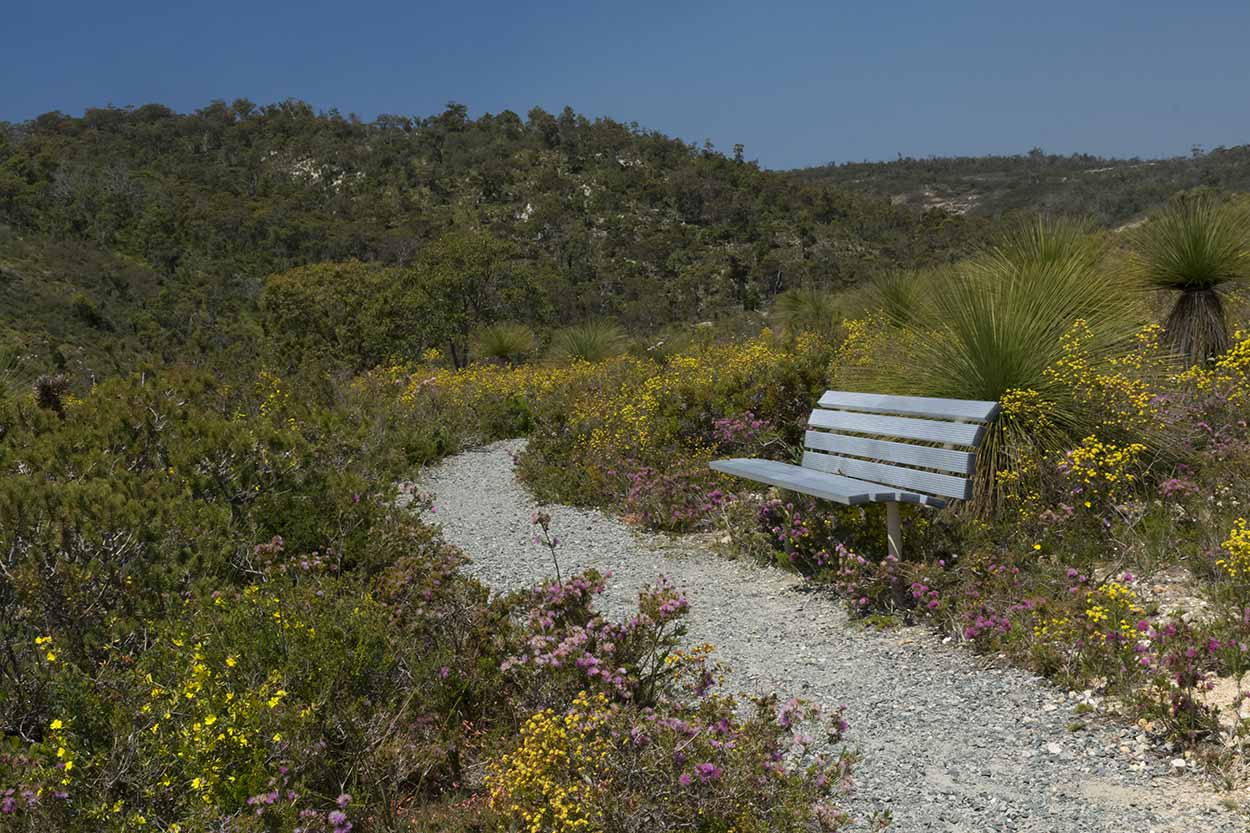
Kalamunda National Park, Beelu National Park and Gooseberry Hill
Walking 1000km along the Bibbulmun Track from Kalamunda in the Perth Hills to Albany is not everyone's cup of tea. But with the Kalamunda Bus Port at the doorstep of the Bibbulmun Tracks Northern Terminus, almost anyone can experience at least a small section of this famous trail.
Apart from adding a feather to your hiking cap, there is also plenty to see, especially wildflowers, bushland panoramas and birdlife. A popular spot is the scenic Rocky Pools, which was a popular swimming hole pre-1930s. The Kalamunda local government provides several marked trails which traverse the area and are well worth exploring. The best time to visit is in the cooler months, especially after winter rains have filled the streams and in late winter and spring when the wildflowers are erupting.

Rocky Pool Walk Trail: Fancy experiencing a small section of the famous 1000km Bibbulmun Track followed by a dip in the scenic Rocky Pools? If so, then the Rocky Pool Walk is for you. Along the way, you can also experience bountiful wildflowers (at the right time of year of course), trickling creeks and small waterfalls, wildlife and valley views. But a word of warning, the Rocky Pool Walk is also rather rocky and steep in sections, but the effort is well worth it. The walk is about 10km long, takes about 3.5 hours, and you can access the hike from Kalamunda Bus Station. Click here for more information.
Helena Pipehead Walk: Follow in my footsteps as I hike through the wildflowers, birdsong and flowing creeks of Kalamunda National Park and Beelu National Park. Along the way, I visit a full flowing Rocky Pools and experience the panoramic views from the Helena River Valley over the Pipehead Dam. The walk is about 13.5km long, takes about 4 hours, and you can access the hike from Kalamunda Bus Station. Click here for more information.
A Bibbulmun Track Experience from Mundaring to Kalamunda: Follow in my footsteps as I traverse 25km from Mundaring to Kalamunda. Along the way, there is plenty of bushland, honkey nut munching Black Cockatoos, both in-use and historic water pipelines, Mundaring Weir, Lake C.Y. O'Connor, phallic rocks, and the scenery of Kalamunda National Park and Beelu National Park. The walk is about 25.4km long, takes about 7 hours, and you can access the hike from either Kalamunda Bus Station or a bus stop in Mundaring. If you need a refreshing ale along the way, try the Mundaring Weir Hotel at the corner of Hall Road and Weir Village Road. Click here for more information.
Statham's Quarry Walk: Enjoying a hole in the ground and an abandoned railway line on a hike around Gooseberry Hill National Park. Join me as I take in the sunrise on an early morning walk which includes panoramic views over the Swan Coastal Plain (you can see all the way to the Perth CBD), plenty of flora and granite outcrops and a bit of local history. The highlights of the hike are the breath-taking views from Statham's Quarry (you can get right next to the sheer cliffs, so watch your step) and walking along the former Zig Zag Railway Line, used from 1891 to 1949 by the Canning Jarrah Timber Company to transport railway sleepers to Perth. The walk is about 18.9km long, takes about 3.5 hours, and you can access the hike at the bus stop near the corner of Gooseberry Hill Road and Hermes Road, Gooseberry Hill. Click here for more information.
Mundy Regional Park and Lesmurdie Falls National Park
Located to the west of Kalamunda and Lesmurdie, Mundy Regional Park and Lesmurdie Falls National Park are accessible from all sides via public transport. There are numerous tracks throughout the area and the Kalamunda local government has provided some fantastic marked trails. My favourite would have to be the Whistlepipe Gully Walk, a 3km trail which loops around the banks of a winding creek with numerous small waterfalls. When the vegetation is lush from winter rains you could swear you are traipsing through a tropical jungle.
Whistlepipe Gully is a great one for the kids, but if you are looking for a hike a bit more strenuous try a couple of the longer walks which loop around the hillier sections of the park. The reward for your effort will be panoramic views across the Swan Coastal Plain and an abundance of wildflowers and birdlife.
The jewel in the crown, however, would have to be Lesmurdie Falls (pictured below), probably the most spectacular waterfall in the Perth metropolitan area. For a close-up view, take the Foot of the Falls Trail along Lesmurdie Brook but be careful hopping along those slippery rocks. For a more panoramic view, take the high road along the southern shoulder of the valley and enjoy aerial views from the observation platforms.

Palm Terrace Walk and Lesmurdie Falls: A great springtime walk with a plethora of wildflowers, 28 parrots and the spectacular Lesmurdie Falls, probably the best waterfall in the Perth metropolitan area. Great views over the Swan Coastal Plain as well. The walk is about 10 km long, takes about 5 hours (significantly less if you take fewer photographs than I do), and you can access the hike via the bus stop on Lewis Road, near Anderson Road in Forrestfield. Click here for more information..
Whistlepipe Gully and Lewis Road Walk: The Whistlepipe Gully walk is a great little walk with small waterfalls, a babbling creek, plenty of greenery (obviously after rains) and foundations of a house which formally crossed the creek to explore. A good option for the kids. If you are feeling more adventurous, try the Lewis Road Walk for panoramic views and a springtime wildflower spectacular. The walk is about 9.2 km long, takes about 4 hours, and the best access is from the end of Orange Valley Road, Kalamunda. Click here for more information.
Korung National Park and Banyowla Regional Park
If wildflowers are on your agenda, then Korung National Park and Banyowla Regional Park are perfect. From Lions Lookout on Welshpool Road East, you can access several marked trails provided by the Kalamunda local government. Banyowla Regional Park, specifically Ellis Brook Valley, is a little harder to access via public transport, but the extra walk is worth it. Ellis Brook Valley is personally one of my favourites.
Ellis Brook Valley Reserve: Ellis Brook Valley Reserve is a Perth hiking gem. If you come at the right time of year you will be amazed by probably the best natural display of wildflowers in the Perth metropolitan area. Try the Eagle View Trail which is carpeted by yellow and pink feather flowers in spring, or scamper through the tunnels of Mouse Ears on the Blue Wren Ramble path. Apart from wildflowers, Ellis Brook Valley Reserve is also well known for the dramatic cliffs and emerald green waters of Old Barrington Quarry, just be careful around the quarry edge, it's a long way down. Scrambling around the rocks at the top of Sixty Foot Falls for panoramic views down the valley and across the Swan Coastal Plain to the Perth CBD is also a highlight. The walk is about 6.9 km long, takes about 2 hours, and can be accessed from the end of Rushton Road, Martin (not the most public transport accessible location, a 4km walk from Gosnells Train Station). Click here for more information.
Victoria Reservoir Walk: The long way to Victoria Reservoir via Lions Lookout is full of history and natural beauty. Along the way, there are babbling brooks, panoramic views, wildflowers, birdlife, the oldest surviving all-timber bridge in Australia, a gigantic Grasstree, a sad end to a young life and dam walls, both the old and the new. The paths around Lions Lookout are steep and rocky, but once you reach the Mason and Bird Heritage Trail and the official Victoria Reservoir Walk, the paths are rather flat and pleasant. The walk is about 15.5 km long, takes about 4.5 hours, and can be accessed from the bus stop near the corner of Welshpool Road East and Crystal Brook Road, Lesmurdie. Click here for more information.
Lions Lookout Walk: An easily accessible walk off Welshpool Road East with plenty of wildflowers and views over the Swan Coastal Plain. Be prepared for some rocky, eroded paths and sweat-inducing vertical gains. A coffee cart often stops at the Lions Lookout carpark, so you can get a caffeine hit before hitting the trail. The walk is about 5.9 km long, takes about 2 hours, and can be accessed from the bus stop near the corner of Welshpool Road East and Crystal Brook Road, Lesmurdie. Click here for more information.
Indian Ocean Coastal Walks
That's enough of the Perth Hills, time to give hikes along Perth's stunning coastline some credit. There are plenty of walks all the way from Burns Beach in the north to Mandurah in the south (one day I hope to walk the whole way). The walks along the coastline are great when the weather heats up and even more spectacular at sunset.

Rockingham Coastal Hike: A 24 km hike along the Rockingham coastline. Take in the stunning views of the Indian Ocean, Cockburn Sound and the Shoalwater Islands Marine Park. Highlights include exploring the jagged limestone cliffs and WWII history of Point Peron, clear blue waters, spectacular sunsets and hiking among the sand dunes of Warnbro Sound. Keep an eye out for dolphins feeding close to shore and enjoy the plentiful coastal birdlife (I once came across a male Splendid Fairywren in full blue mating plumage hopping about in the vegetated dunes of Warnbro Sound). The walk is flat, and the majority of the paths are concrete, with some beach and gravel walks. Don't feel like hiking the whole way? There are plenty of car parking facilities and public transport options along the way, so you can cut the hike into smaller trips. Click here for more information.
Burns Beach to Hillarys Boat Harbour: Stunning coastline scenery and all easily accessible by public transport. Highlights include the path through the Iluka Beach dunes, probably the best ocean-side walk in the Perth metropolitan area, plenty of sandy beach walking options and you can top it off with a beverage or meal at one of the many establishments at Hillarys Boat Harbour. The walk is about 14 km long, takes about 3.5 hours, and can be accessed from the bus stop at Burns Beach or near Hillarys Boat Harbour. Click here for more information.
Walking the Banks of the Swan River
I'm not sure the exact length of the Swan River's perimeter, but whatever it is it's huge. This means plenty of walking opportunities. But where to start?

Heirisson Island to The Narrows Loop Walk: An 11.2 km loop along the Swan River banks of Perth City, Heirisson Island, and South Perth. Cross the river at the Narrows Bridge and the Causeway and treat yourself to brilliant river and city views. Along the way make a stop at Heirisson Island and say hello to Perth's inner-city kangaroo residents. Yep, that's right, roaming kangaroos all within minutes of downtown Perth. There is plenty of bird life, people watching opportunities, grassy spots to take a rest and the possibility of a dolphin sighting in the waters of the mighty Swan. The path is flat and very well serviced the whole way. Although a popular spot for Perth locals to work up a sweat the loop is perfectly suited for a leisurely stroll enjoyed over a morning or afternoon. If you are more of a night owl this walk is ideally suited for a night walk, sure the Kangaroos on Heirisson Island will be impossible to spot but the glow of the city lights viewed from the South Perth foreshore should keep you captivated. The walk is about 11 km long, takes about 3 hours, and can be accessed from many locations, the most likely being the Elizabeth Quay Bus Port or Train Station. Click here for more information.
Canning Bridge to Fremantle via the South Bank of the Swan River: At 21km this is rather a long walk, but there is plenty to see along the way including spectacular river views, Point Walter Spit (a sandbar that extends over 1km into the river at low tide), parklands, riverside bushland and rock formations, cafes to sample, black swans, and a glimpse into the lives of Perth's wealthy (including Australia's most expensive house at $57.9 million). Also, keep an eye out for the local dolphins feeding close to the shore. The walk is about 21 km long, takes about 5 hours, and can be accessed at each end via Canning Bridge Train Station or Fremantle Train Station. Click here for more information.
Perth Lakes
The Perth metropolitan area is dotted with many small to medium sized lakes which make ideal loop walks. If you enjoy wetlands and birdlife these are the areas you will want to try.

Lake Monger and Herdsman Lake: Perth's inner city lakes with ample natural beauty and easily accessible via public transport. Along the path, there are plenty of birdwatching opportunities (including some birdwatch huts), eerie paperbark tunnels, water and CBD views, and a swampland boardwalk. The walk is about 18 km long, takes about 4.5 hours, and can be accessed by several bus stops along the trail and from either Leederville or Glendalough Train Stations. Click here for more information.
Lake Joondalup and Yellagonga Regional Park: Easily accessible from Joondalup Train Station and the biggest lake in the Perth metropolitan area. Despite being the biggest lake, close encounters with the water are few but there is plenty of bushland to enjoy. Along the way, you will meet the local kangaroos and birdlife, pass through the symmetry of a pine plantation and add the "I have walked around the biggest lake in Perth" feather to your cap. The walk is about 19 km long, takes about 4 hours, and can be accessed from Joondalup Train Station or bus stops on Wanneroo Road. Click here for more information.
North and Bibra Lakes of Beeliar Regional Park: Plenty of bird watching opportunities in this lake system nestled in Perth's southern suburbs. I have never seen so many ducks in one place, but apart from the ducks are plenty of Black Swans, Swamphens and birds I have no idea what are named. The walk is about 18 km long and takes about 4 hours if you start and finish at Murdoch Train Station. If you want to get closer to the lakes try bus stops on Farrington Road or to the south of Bibra Lake. Click here for more information.
The Spectacles: Located close to Kwinana Train Station, The Spectacles lake system is worth a look (worth of "look", get the pun? The Spectacles are named so as they look like a pair of spectacles from above), especially when the wildflowers are in bloom. My favourite is the 3.2km Banksia Walk Trail, which has many more flowers than just Banksia. The Biara Lookout, which is accessed via a 250m boardwalk through Paperbark trees deep within the lake, is another highlight. The walk is about 16km if you start and finish at Kwinana Train Station and walk the main signposted trails (Banksia Walk Trail and the 4.4km Aboriginal Heritage Walk Trail). It takes about 4 hours to complete. Click here for more information.
Lake Cooloongup Flora and Fauna Reserve: A great walk between Rockingham and Warnbro Train Stations. Plenty of sandy trails through bushland and sections filled with an explosion of yellow from flowering wattle groves. Plenty of kangaroos and birdlife but very few humans. The path I took is about 11km long, taking about 3.5hr. Click here for more information.
John Forrest National Park
Western Australia's first national park has plenty to see and do, ranging from historic railway heritage, waterfalls, abundant flora (I saw my first ever wild Spider Orchid here) and fauna, a plethora of walking trails, picnic facilities and even a tavern for a cold beer after a long day of walking.
If you are a keen hiker take on the trails, such as the Eagle View Walk Trail, which explore Jane Brook and the northern sections of the park. However, if you are looking for something a little more leisurely try the section of the Railways Reserve Historic Trail which runs through the park. There is plenty to see along this flat and easy trail, including waterfalls and the abandoned 340m long Swan View tunnel (bring a torch!).

The Eagle View Walk Trail: At 15km, it's not the longest hike, but expect the walk to take plenty of time (it took me about 5 hours!) due to the sheer number photo-worthy spots. The southern section snakes its way along the lush Jane Brook (alternatively you can take the ridgeline trail, but I suggest go along the brook) and then the trail loops into the northern sections taking in the Eagle View Lookout and an amazing floral show in late winter and spring. National Park Falls and Hovea Falls are a highlight after good rains. I accessed the trail from the bus stop on the Great Eastern Highway and walked along Park Road to join the official Eagle View Walk Trail (in total about 21km in 6 hours), but the bus stops near the Pechey Road Carpark in Swan View are another alternative. Click here for more information.
Railways Reserve Historic Trail: If you are looking for an easy walk trail with plenty of bang for your buck, then the Railways Reserve Historic Trail is for you. There are two waterfalls (National Park Falls and Hovea Falls), panoramic valley views, railway history, wildlife, wildflowers and the somewhat eerie walk through the 340m long Swan View tunnel. To make the walk even more relaxing, take a pitstop at the John Forrest Tavern for a refreshing beer and a good pub meal. Click here for more information.
Click Here To Read More ...
Click Here To Read More ...
View Photographs
Trails WA: A top resource for hiking information in Western Australia.
Hello, I'm Marc and welcome to metrotrekker.
Be it seeing the city sights, exploring parklands and gardens, urban walks or day-hikes in the city outskirts, the metrotrekker website details walking routes and hiking trails accessible by foot and public transport in metropolitan areas.
The metrotrekker website provides you with all the details required for metropolitan exploration:
- a map with geolocation and a selection of map types (street, satellite, topographical)
- navigation formats compatible with common GPS devices, desktop browser/software or mobile apps
- trail length and difficulty
- start and finish options (particularly by public transport)
- photos/videos
- attractions or points of interest along the way
- other walks and hikes nearby
- often a story or detailed description of the trail (I have personally walked every single trail on the website)
- a comments section, so feel free to write about your experiences as well
- and more improvements and resources are continually being added
So let's get outside and explore our great metropolitan areas by foot. Click Here to begin exploring with metrotrekker.
Pleasant Trails,
Marc
Links To Help You Navigate