- Start or End: I started at the Central Ferry Pier (Google Map Directions) and finished at The Peak Galleria Bus Station (Google Map Directions).
- Length: 7.7km (4.8mi) in about 2.5hr
- Grade: Medium to Hard. Up the whole way but at least it is paved. I have never walked the opposite direction, but I can safely say it would be easier.
- Date Walked: 9th of November 2014
I hate queuing so much that I walked to the summit of The Peak. Lucky I love walking. Should have walked back down too.
It has been a very big day. Five walks already done. Sure, walking around parks and temples isn't the most strenuous activity but I have been on my feet all day. Time to give my feet a rest and visit The Peak on Hong Kong Island (also known as Victoria Peak) via two famous forms of Hong Kong public transport, the Star Ferry and the Peak Tram. As the name suggest, The Peak is a peak. A peak south-west of Hong Kong Central which provides amazing views of the bustling city below. The Peak is a major tourist draw card. I don't think you can really say you have done Hong Kong if you haven't visited The Peak. The same can probably be said about the Star Ferry and the Peak Tram.
After dinner in Tsim Sha Tsui I hop aboard the Star Ferry bound for Hong Kong Island from the Star Ferry Pier located on Salisbury Road, Tsim Sha Tsui. According to Wikipedia the history of the Star Ferry dates back to 1888 when the merchant Dorabjee Naorojee Mithaiwala purchased a number of steam powered ferries (two of which were called the Morning Star and Evening Star, hence the name of the company today) and founded the Kowloon Ferry Company. Despite a name change The "Star" Ferry Company, as it is known today, has been hauling passengers across Victoria Harbour for over 100 years. Today approximately 70,000 passengers cross Victoria Harbour via a fleet of 12 ferries everyday (that's about 26 million a year!).
I tried to take some pictures while on the Star Ferry, but it is hard to take good shots when there is very little light and the boat is a swaying. The two below are the better ones. With the sturdiness of a tripod and the ability of long exposure times I hope to capture much better photographs at The Peak.
Click Here To Read More ...


With one iconic form of public transport complete it is time to try another, the Peak Tram. The Peak Tram lower terminus is located at the intersection of Garden Road and Cotton Tree Drive, a short walk from the Star Ferry Terminal at Hong Kong Central. Along the way I pass two iconic Hong Kong buildings in their night time colours.


Like the Star Ferry, the Peak Tram also has a long history. According to the thepeak.com.hk the first service commenced in 1888, the same year as the Star Ferry. 1888 was definitely a year for improved public transport services in Hong Kong. The Peak Tram was devised by Scotsman Alexander Findlay Smith as a means of increasing the speed of residential development in the hill districts. When completed the Peak Tram was the first cable funicular in Asia with a length of 1,350 meters and an elevation change of 368 meters (that's a gradient of 4�27 degrees, that is, steep!).
The Peak Tram is a tourist drawcard as it is the most direct route to Victoria Peak and the associated shopping and dining options located at the top. It is also popular due to the history, the steepness of the ride and the views over Hong Kong. I reach the Peak Tram Garden Road Terminus with excitement.

The excitement is quickly deflated when I place myself at the back of a very long queue for the Peak Tram. I hate queues. I really hate queues and I despise queues that move slowly. I am not going to last long here. Time to make a decision. Wait in line or give up and go home. Wait a second! I'm a metrotrekker. I should walk to the top of The Peak. Great idea! I will probably beat those people in the line anyway. Come on tired feet and legs, you can do this. So I do. Here are some pictures I took on the way up.


Not sure if the route I took was the most direct (I got lost in the darkness of the Hong Kong Zoological and Botanical Gardens), but I made it. After all of today's walking, hiking up to The Peak was probably not a good idea. By the time I got to the top I was dripping in sweat. I also forgot to bring water with me (I wasn't planning on doing this). Dumb thing to do. I was wearing jeans as well. Another dumb thing to do. Luckily there was a 7-eleven at the top so I consumed two bottles of Gatorade and felt a lot better. It was a tough walk, but definitely worth it.
For the majority of the walk up Victoria Peak I hardly came across anyone (except for people in cars and buses of course). That all changed when I reached The Peak. There were people everywhere. The Peak is definitely a tourist drawcard. One of the attractions is the Sky Terrace 428 located at the top of the Peak Tower. It is said to boast "stunning 360-degree panoramic view across Hong Kong".

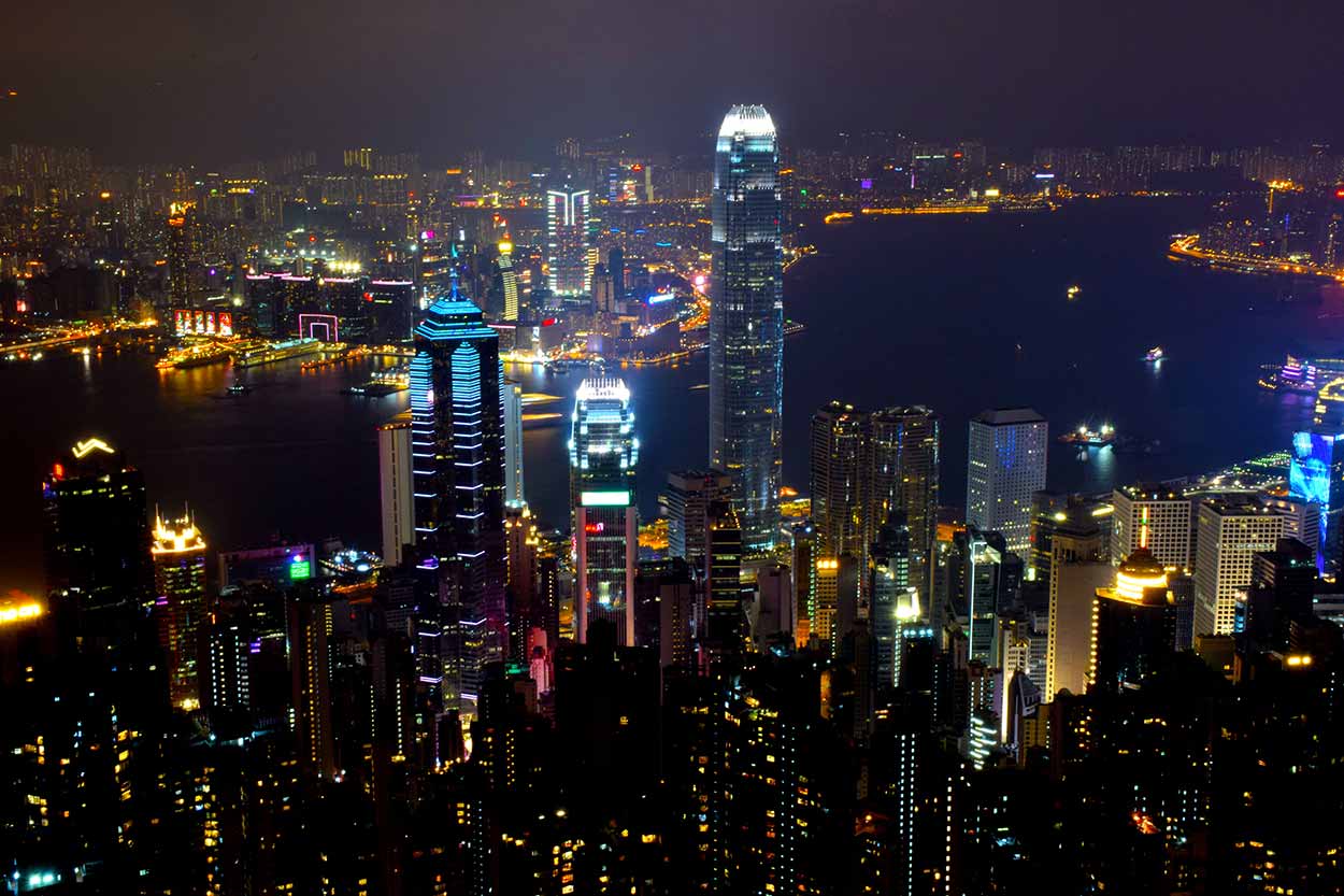
However, at HK$48 a ticket and probably crowded with people I think I'll pass. Instead, I will walk along Lugard Road which also just happens to be the start of the Hong Kong Trail Section 1 (a trail I plan to complete in the coming days when the sun is out, see here). After about 5 minutes walking in the dark I come across a spot with breathtaking views of Hong Kong city below. I set up my tripod and program the camera for night time photography (i.e. long exposure time). Here is the result.


Pretty cool huh? In hindsight, I really should have tried a video as well because the visual spectacular above had a soundtrack. The city had a roar. I was surprised how noisy it was all the way up here.

I was also surprised by the lack of people on Lugard Road. With all the crowds around The Peak Tower I wonder why hardly anyone bothers taking that extra walk to get the views for free. Their loss is my gain.
After about 45 minutes enjoying the views I decided to finally call it a day. It has been a big one. I think tomorrow I will have a sleep in, buy some new clothes and then visit the International Commerce Centre (ICC), the tallest building in Hong Kong. This one ...

Now how do I get back to my hotel all the way back in Yau Ma Tei? The Peak Tram? No, the line is even longer than it was back down at Garden Road. Walk down? No Marc, No. Take a minibus? Yes! Why I didn't think to take one up I will never know, but I'm still proud of my walking achievement.
I Google Map to find the next minibus to Central Station and hop aboard. My first minibus ride! Another feather in my cap. However, what I thought was a minibus wasn't a minibus at all. It was a scary rollercoaster. And I thought the walk up was tough. It was nothing compared to the ride down. The bus driver must have been channelling Lewis Hamilton and raced down the windy, steep roads in a personal best. I was in the back seat getting flung all over the place. Is this normal? It didn't seem to be bothering the people next to me. And then it happened. There was a distinct smell in the air ... puke ... some poor person in the front vomited. I feel so sorry for them and I can't blame them. It was the scariest rollercoaster I have ever been on. I call it the Vomitron, Hong Kong's next big attraction. For the rest of the ride down I stuck my head out the window. The vomit smell was just too overpowering.
At the end of the Vomitron ride I was expecting to be forced to walk through the gift shop where I could purchase a picture of myself "enjoying" The Peak Vomitron theme park ride. Or possibly pick up a snow globe or a tea towel to take back home. But no, no trinket to take home and prove I did it. Hopefully the train ride back to Yau Ma Tei is much less exciting. Fortunately it was, and I survive to hike another day in Hong Kong.
Click Here To Read More ...
Click Here To Read More ...
Click Here To Read More ...
View Photographs
Hello, I'm Marc and welcome to metrotrekker.
Be it seeing the city sights, exploring parklands and gardens, urban walks or day-hikes in the city outskirts, the metrotrekker website details walking routes and hiking trails accessible by foot and public transport in metropolitan areas.
The metrotrekker website provides you with all the details required for metropolitan exploration:
- a map with geolocation and a selection of map types (street, satellite, topographical)
- navigation formats compatible with common GPS devices, desktop browser/software or mobile apps
- trail length and difficulty
- start and finish options (particularly by public transport)
- photos/videos
- attractions or points of interest along the way
- other walks and hikes nearby
- often a story or detailed description of the trail (I have personally walked every single trail on the website)
- a comments section, so feel free to write about your experiences as well
- and more improvements and resources are continually being added
So let's get outside and explore our great metropolitan areas by foot. Click Here to begin exploring with metrotrekker.
Pleasant Trails,
Marc
Links To Help You Navigate