- Start or End: Loop walk starting from the end of Stocker Road with public transport access from Brookton Highway, Roleystone (Google Map Directions).
- Length: 10km (6.2mi) in about 4hr
- Grade: Medium to Hard. All gravel trails with both low and high gradient slopes. Family friendly flat section on the southern section of the loop.
- Date Walked: 15th of May 2016
A smoky start followed by a rock face and Kangaroos on the Kangaroo Trail. Too bad there were no Echidnas on the Echidna Trail to save me from the ants.
It's Saturday so it's time for a walk. After more inspiration from The Life of Py I decide to try the northern section of the Wungong Regional Park near Roleystone. The Life of Py details a number of trails in the area that he found out about via Bill from the Roleystone Bush Care website. Think I might check these out myself. So I leave early and plan to catch the train to Kelmscott and then take the 241 bus to the corner of Stocker Road and the Brookton Highway. My plans change when I realise the Armadale Train Line is closed today due to work at the new Perth Stadium Station. I really don't want to catch a rail replacement bus so I say stuff it, get a coffee and head home.
Fast forward to Sunday morning. The trains are now functioning on the Armadale line. I catch the 7:30am train to Kelmscott, take the 241 bus at 8:21am and arrive at Stocker Road at about 8:30am. I am a little concerned about the amount of smoke in the area. Even at Kelmscott station the smoke is thick in the air. Knowing my luck, I have arrived in a bushland burn off period. I check the Western Australian Parks and Wildlife Website (a great website to check out before you go for a bushwalk), but no planned burn off today. Oh well, not sure where this smoke is coming from but I'll try anyway.
From the bus stop on Brookton Highway it's a short walk up Stocker Road, over the narrowest section of the Canning River I have even seen and then to the gate of the Wungong Regional Park.
Click Here To Read More ...

Just beyond the gate is an eerie old farm shed. Even more eerie with the hovering smoke.

I continue along a slightly uphill gravel path. Supposedly this is the Echidna Trail (according to Bill) but I cannot see a single trail marker or sign. I reach my first T-section soon enough and decide to take the flat route suggested by The Life of Py along the Canning River. At the T-section of the Echidna Trail there is a perfectly positioned bench seat.

I really don't deserve a rest yet as I have only been walking for a few minutes. But the amount of smoke in the air is really irritating my throat and I have quite a cough. I persevere.


A really great and relaxing walk along this stretch (apart from the smoke). You don't get to see the Canning River much itself but you can hear it flowing in the distance. The smoke in the air is adding a real eerie flavour once again, that and the fact I haven't seen another person at all. Feels like a scene from the Blair Witch Project.

The trail in the picture above is not the actual Echidna Trail but a random track probably made by the kangaroos. There are a few kangaroos about, but they are rather flighty and not the most conducive to photography. So kangaroos on the Echidna Trail, but as of yet no echidnas.
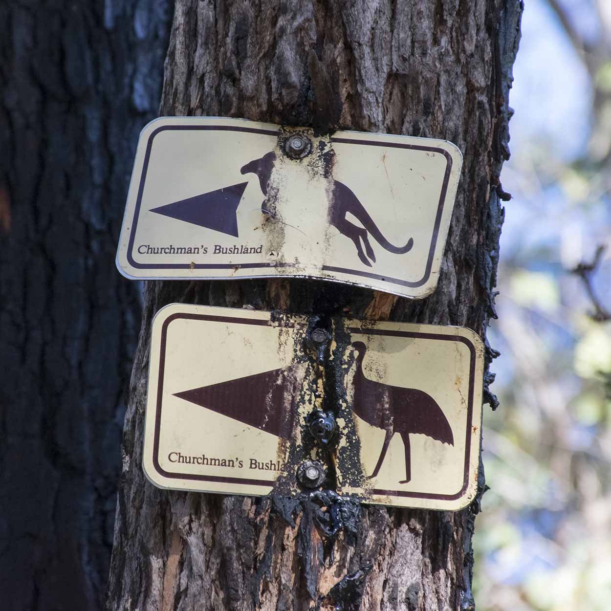
I come across my first obvious sign.

So this area is also called Churchman's Bushland. According to the sign you can access the Canning River thanks to the weed control undertaken by the Churchman's Bushland Association. Nice work, there is hardly a weed insight. If you walk past this sign you can catch a glimpse of the Canning River, but it's not much of a river this far inland. More of a fast flowing creek. The native vegetation is thick enough near the river edge so I didn't get that close to take a good picture.
The surrounding area along the Canning River is more like parkland than a bushland setting (even though it is called Churchman's Bushland). In a number of cases there are large grassed areas and there is little undergrowth. Mainly medium to large sized trees with very green (it has been raining) low grass. This setting along with the abandoned farm shed makes me think that this area was once used for farming.

The Echidna Trail leaves the banks of the Canning River and heads south. And it heads south uphill. Needed to have a rest a couple of times on the way up.

As I rise the smoke starts to clear and I come across my first trail marker for the Echidna Trail. The trail marker takes me off the clear, wide and rocky track and into the bushland.


Along the bushland track I come across this specimen.

What a weird looking plant. I think it is an example of a Zamia (Macrozamia fraseri, a type of cycad) when it is fruiting (the red bits are the fruit). After a bit of a Google search it seems that the fruit is edible if properly treated. If you eat fresh from the plant it is poisonous. Please don't trust my bush tucker skills though. The fruit looks inviting but I think I will stick to the ziplock bag of nuts and the muesli bars in my backpack thanks.
I continue up the bush track of the Echidna Trail and get my first view above the smoke and into the hills.

Unfortunately, I unwittingly took this photo from the top of a massive ant's nest. Obviously the ants didn't like it and they started to attack. I was made to scamper away while trying to brush them off. Ok, time to tuck my pants into my socks.

The ants did not want to let go. They must be interested in transport to the 30m high rock face further along the track.


What a really great spot for a walk. I haven't seen anything like this on my walks around Perth. There are plenty of cliffs around Perth but mostly man-made (i.e. abandoned quarries) or at a shoreline. This rock face is all natural and just appears out of nowhere. The rock face is made of dolerite, is 140m long and up to 30m high.

The cliff is a popular abseiling spot for obvious reasons, however there is no one swinging around today. There don't appear to be any bushrangers hiding around here either. During the 1800's this exact spot was supposedly used by Moondyne Joe, Western Australia's best known Bushranger, as a hideout from the authorities. I wonder if he had the same ant problems I do? Wouldn't be that pleasurable hiding out from the police with your pants tucked into your socks the whole time.
Once I hit the wall I walk east. Not sure why I went this way, probably because it was the most obvious path and it was going up. For some reason I though the path would take me to the top of the cliff but it didn't.

In hindsight I really should have taken a look along the path heading west from the cliff. There must be a way to reach the clifftop and on the way find Moondyne Joe's cave hideout. Anyway, the upward eastern path takes me to a carpark area and the first people I have seen all morning. After the Echidna Trail climb I deserve a rest.

As I rest I contemplate my options. Should I take the Botanical Walk Trail, the Kangaroo Walk Trail or the Emu Loop Walk Trail? Think I will just walk the same path as The Life of Py, which appears to be a mixture of the Kangaroo Walk Trail and the Emu Loop Walk.

After the ants and the hills it's nice to back on a wide flat path. Time for a relaxing stroll. As I head north-west I come across an old airfield ...

fading trail markers ...
acreage views ...

more wide bushland tracks ...

kangaroos on the aptly named Kangaroo Walk Trail (no emus on the Emu Loop Walk Trail unfortunately) ...

a black horse ...

and views over the Swan Coastal Plain.

The most westerly section of the walk is within a large grassed section between the bush and the suburbs.

But soon enough I am heading back in a north-east direction and within the bushland.

Nothing that exciting along this stretch of the loop, just nice bushland tracks with the occasional obstructed view to the north.

I reach a fork in the road. Do I head north downhill and complete the loop, or go south uphill to see if there are some better views up the hill. I have plenty of time until the next bus comes so I might as well take a look up the hill. I am not disappointed when I find a rocky outcrop beside the path with great views to the north-east.


It was a bit of a climb but well worth it. Easily the best views all day. Perfect spot for a rest and some food.
From the rocky outcrop I did venture a bit higher to find some more views but then stopped once the vegetation started to thicken up again.


Ok. It's time to go home. I have really enjoyed my walk around Wungong Regional Park and the Churchman's Bushland. Downhill I go.

On the way I notice a Monarch Butterfly. I have never successfully captured a photograph of one as they flutter about too much. But this one is a bit more passive. Click!

Got a picture. Not the best, but happy I finally got one. Unfortunately, I didn't realise that this entire time I have been standing on an ants nest again. This time they are really angry. I am absolutely swarmed. I run away screaming like a little girl while attempting to squat them off. Thank God I still have my pants still tucked into my socks. If I didn't, my pants would have surely been removed. Now that would be a sight, a 30 something year old man with no pants, running down a bush track smacking himself while screaming like a little girl. Luckily it didn't come to that.
An ant even reached my ear. Pesky little buggers, but unbelievably I didn't get bitten. Once the majority were gone I had the opportunity to take a picture of them.

The picture really doesn't do the swarm justice. It was much, much worse.
As I continue to swipe away ants a couple meets me on the trail and asks if I am ok. "Thanks, I'm all good, but I suggest that you tuck your pants into your socks and watch out for ants". Funnily enough, they completely ignore my advice and continue along the trail. Oh well, best of luck.
I continue to where I started the walk at the abandoned farm shed. Think I might have a look inside.


As I leave Wungong Regional Park and head towards the bus stop I see the couple I met moments later returning. "We brought some ants back for you", the male said. I laugh. I think they believe me now.
A really great walk and I would definitely return. It was a real pity about the ants, but that's just part of being in nature I guess. Just remember to tuck your pants into your socks.
The walk was 10km long and took me about 4 hours.
Click Here To Read More ...
Click Here To Read More ...
Click Here To Read More ...
View Photographs
Hello, I'm Marc and welcome to metrotrekker.
Be it seeing the city sights, exploring parklands and gardens, urban walks or day-hikes in the city outskirts, the metrotrekker website details walking routes and hiking trails accessible by foot and public transport in metropolitan areas.
The metrotrekker website provides you with all the details required for metropolitan exploration:
- a map with geolocation and a selection of map types (street, satellite, topographical)
- navigation formats compatible with common GPS devices, desktop browser/software or mobile apps
- trail length and difficulty
- start and finish options (particularly by public transport)
- photos/videos
- attractions or points of interest along the way
- other walks and hikes nearby
- often a story or detailed description of the trail (I have personally walked every single trail on the website)
- a comments section, so feel free to write about your experiences as well
- and more improvements and resources are continually being added
So let's get outside and explore our great metropolitan areas by foot. Click Here to begin exploring with metrotrekker.
Pleasant Trails,
Marc
Links To Help You Navigate