- Start or End: Start or end at either Perth Train Station (Google Map Directions) or Bassendean Train Station (Google Map Directions).
- Length: 20.3km (12.6mi) in about 4hr
- Grade: Medium. Paved much of the way with some boardwalks and dirt paths. Flat with a few small hills. Long.
- Date Walked: 3rd of May 2014
Plenty of wetland walks along with wet dogs, discourteous gardeners and the home of Australia's latest paedophile suspect.
The journey to conquer the Swan River continues. Today I plan to walk the north bank of the Swan River from the Windan Bridge at East Perth to the Guildford Road Bridge, which links Bassendean and Guildford. But before I take on this section I need to get to the Windan Bridge. After a walk to Rockingham train station, a train to Perth Underground, and then a walk to Windan Bridge (via a path I have walked previously), I finally make it to Windan Bridge and head north along the banks of the Swan River.
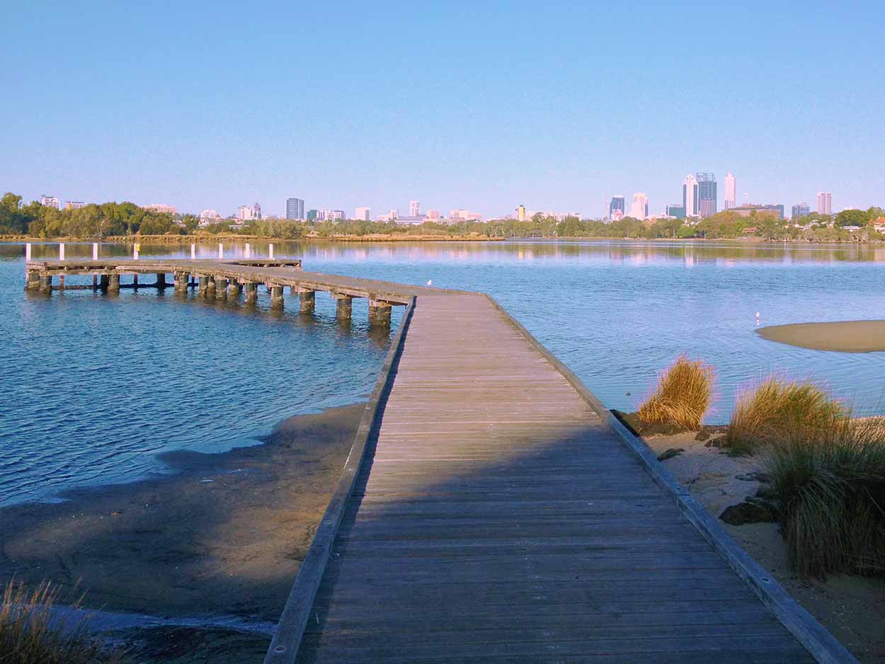
The first place of interest on my walk today is the Tony Di Scerni Pathway which stretches along the banks of the Swan River from Banks Reserve to Bardon Park. It starts just north of the Windan Bridge. The Tony Di Scerni Pathway is a brilliant walk amongst the wetlands of the Swan River and a highlight would have to be a small jetty which allows some great views of the river, with the Windan Bridge and the Perth CBD in the distance.
Click Here To Read More ...

So who is this Tony Di Scerni guy anyway? And what did he do to deserve an awesome path named after him? I really couldn't find that much on him, apart from the City of Vincent website where it states that Tony Di Scerni was the founding chairman of the Banks Reserve Precinct Group. Anyone know any more about this chap?
The Tony Di Scerni Pathway ends at the eastern side of Bardon Park, but an unnamed path continues around the Maylands Yacht Club to Berringa Reserve. Before heading into Berringa Reserve I take a detour down East Street to the Maylands Yacht Club jetty. Definitely worth the extra few steps off the main path.
Getting back onto the path the walk through Berringa Reserve consists of suburbs to the north and to the south more Swan River wetlands and large areas of lawn. Disappointingly, the path heads away from the river due to the Maylands Peninsula Golf Course hogging the river bank. Fortunately, and to my surprise, the walk was significantly improved with the sighting of the Old Maylands Brickworks on Swan Bank Road, directly across from the golf course club house.

The Old Maylands Brickworks was constructed in 1927 with an initial capacity of 7 million bricks a year and continued operation until 1982. The clay for the bricks was sourced from two large clay pits, which today have filled with water to create the nearby Lake Bangana and Lake Brearley. Initially the Old Maylands Brickworks was set for demolition, but public outcry saved the site and restoration work was undertaken to preserve the buildings. Unfortunately, there is no public access to the Old Maylands Brickworks site, so instead I have to observe the old kilns and the 34 meter high chimney from the path.
I return to the banks of the Swan River at Maylands Foreshore Reserve where I am greeted with more wetland and water views. Perfect spot to rest, rehydrate and consume some nourishment in the form of nuts and fruit.

The path continues at length along parkland on the banks of the Swan River until the northern end of Tranby Reserve, where a diversion from the river takes me into the suburbs for a short time. The path deviates away from the river at the aptly named Swan View Terrace. I guess the path departs from the river so the rich people on the east of Swan View Terrace can have their personal view of the Swan River unobstructed by pesky walkers like me.
Despite having my views of the Swan River obstructed by the substantial houses on Swan View Terrance an interesting series of events did occur. As I walked along Swan View Terrace I encounter a local resident whipper snippering the edges of his lawn and the path. Generally when this happens the whipper snipperer stops as I get close, I guess as a courtesy to stop grass, possible stones or whipper snipper cord being projected at me. But this guy just kept going despite my obvious presence. Sure I got a few light projectiles at my legs, but nothing major, so I didn't care. However, the older lady of a couple walking in the other direction at the same time did care. She amusingly shook her arms in the air and yelled at him over the noise of the power tool and his earmuffs until he stopped. The whipper snipperer then got a good verbal spray, far exceeding the cut grass spray that we path walkers just endured. Good on her though, he really should have stopped for the few seconds necessary.
With a smile on my face bought about from neighbourly disputes I leave the suburbs and hit the path through the Baigup Wetlands.

I have lost count of how many wetland walks I am completed today, but I am more than happy to walk through more at the Baigup Wetlands. A really nice walk and finished off brilliantly with a boardwalk allowing access to the depths of the wetlands and the water of the Swan River.

From the boardwalk there are good views of the Swan River and the Garrett Road Bridge, Western Australia's longest timber traffic bridge. Well, Garrett Road Bridge is actually two adjacent bridges, one constructed in 1935 and another constructed in 1972, the youngest of which can be seen below.

Upstream of the Garrett Road Bridge is the aptly named Garrett Road Bridge Park which includes a random boardwalk in an area thick with vegetation. Not sure what the significance of the boardwalk is, but I explored it nonetheless.

After the completion of the random boardwalk I head into the Bayswater Riverside Gardens, a large cleared parkland on the banks of the Swan River that appears very popular. There are dogs and kids running around everywhere. The busiest spot of all is a little beach area which is full of dogs running amok in the water. Even though it is a perfect autumn day I really should have bought my raincoat, not because clouds are amassing above but with all these wet dogs hanging around it was only a matter of time before I received a shower from a wet shaking dog. Swear I smell like a wet dog now.
Near the little beach is a small jetty terminating with a shelter. It's a great spot to view the Swan River, the Garratt Road Bridge and the Ascot Racecourse on the opposite bank.

The path continues along wetlands, under the Tonkin Highway and into the quiet Claughton Reserve and Ashfield Parade Reserve, where I take a rest on a bench overlooking the Swan River. As I munch on nuts, rehydrate and apply some sunscreen I watch kayakers drift slowly down the Swan River.

After a well-deserved rest the path leads into the suburbs for a few minutes, before returning to the Swan River on the path alongside Ashfield Parade. Suburbia is left behind at the end of Ashfield Parade when the path heads into Ashfield flats, a large natural area allowing the opportunity for a peaceful walk along the river bank.

I'm really glad I enjoyed the serenity of the Swan River lapping at the Ashfield Flats because this was the last time I set eyes on water. Apart from Pickering Park and Point Reserve, the remainder of the Swan River bank to the Guildford Road Bridge is taken up by residential land. I could have stepped off the main path and into Pickering Park or Point Reserve to see the river again, but by this time I was ready to go home.
I planned to reach the Guildford Road Bridge but instead headed to the Bassendean Train Station. In hindsight it would have been quicker to actually go over the Guildford Road Bridge to the Guildford Train Station. But I'm glad I didn't, as Bassendean is home to several significant historical buildings, some of which are on the State Register of Heritage Places, including the Pensioner Guard Cottage at 1 Surrey Street.

The Pensioner Guard Cottage was built around 1856 to house the families of Pensioner Guards, retired soldiers of the British Army who were employed to guard convicts and to carry out other military duties.
On the subject of convicts, Bassendean is the birthplace of Rolf Harris, the "Boy from Bassendean", the well-known entertainer who is now charged with nine counts of indecent assault and four counts of production of indecent child images. Funnily enough, the trial of Rolf Harris begins in 3 days.
Anyway, that's enough about suspected paedophiles from Bassendean. It's time to head home. I really enjoyed todays walk, the path was clearly defined and apart from the end section I hardly had to venture into suburban streets. If you are interested in walking amongst wetlands this is definitely the walk for you.
Click Here To Read More ...
Click Here To Read More ...
Click Here To Read More ...
View Photographs
Hello, I'm Marc and welcome to metrotrekker.
Be it seeing the city sights, exploring parklands and gardens, urban walks or day-hikes in the city outskirts, the metrotrekker website details walking routes and hiking trails accessible by foot and public transport in metropolitan areas.
The metrotrekker website provides you with all the details required for metropolitan exploration:
- a map with geolocation and a selection of map types (street, satellite, topographical)
- navigation formats compatible with common GPS devices, desktop browser/software or mobile apps
- trail length and difficulty
- start and finish options (particularly by public transport)
- photos/videos
- attractions or points of interest along the way
- other walks and hikes nearby
- often a story or detailed description of the trail (I have personally walked every single trail on the website)
- a comments section, so feel free to write about your experiences as well
- and more improvements and resources are continually being added
So let's get outside and explore our great metropolitan areas by foot. Click Here to begin exploring with metrotrekker.
Pleasant Trails,
Marc
Links To Help You Navigate