- Start or End: Start and end at Gosnells Train Station (Google Map Directions). If you have a car, drive to the reserve itself as it is much easier (Google Map Directions).
- Length: 17.5 km (10.9mi) in 4.5hr
- Grade: Easy to Medium. Mainly flat gravel paths, but if you wish to reach the top of the falls you will need to go up then down, but it's not that bad. Be careful around the quarry and the top of the falls, it's a long way down.
- Date Walked: 19th of September 2015
A walk amongst the best display of natural wildflowers in the Perth metropolitan area.
Pssst ... I know a secret. I know the location of the best natural display of wildflowers in the Perth Metropolitan area. And guess what? I'm not going to tell you ... It's Ellis Brook Valley Reserve. Sorry, I had to spill the beans (I'm also sorry for insulting your intelligence. What is the title of this blog post after all?). How could I write about one of my best walking adventures around Perth and not tell you the location. That would just be mean.
In all truth, the wildflower display at Ellis Brook Valley Reserve isn't that much of a secret. I learnt it from the modern day grapevine of Twitter and Instagram. But it isn't just the wildflowers that Ellis Brook is famous for, there is also the Sixty Foot Falls and the Old Barrington Quarry.
So how do I get to Ellis Brook Valley Reserve? Think I will use Google Map directions with the public transport option (I don't own a car after all) to work it out. Oh no! According to Google Maps there is no way to access Ellis Brook Valley Reserve without a car. I challenge you Google Map directions! To me it looks like I can walk from Gosnells Train Station via Station Road and take a short cut to Ellis Brook Valley Reserve by walking across the Tonkin Highway. Google directions doesn't allow such a highway crossing, but from a bit of research using Google Street View it appears such a crossing is possible. Sorted � I hope.
I wake up early and leave Perth City by train heading to Gosnells station. From the station I walk to the other side of the Albany Highway and north-east along Station Street until I hit the Tonkin Highway. Thank God, I can cross. I only have to jump a few small fences to make it to the other side. I was so worried I would find a dead end and then have to backtrack and take the long convoluted route that Google Maps suggested. From the Tonkin Highway it is a simple walk south-east along Quarry Road and then north-east along Rushton Road to my final destination. In total the walk from Gosnells train station is 3km and nothing too strenuous (you do get barked at by a number of large dogs behind fences though).
As soon as I step foot into the reserve I see wildflowers. But first things first. I need to go to the toilet. From the Ellis Brook Valley Reserve Map it appears that the only toilet is at the entrance, so I better go now before I venture too deep into my walk. I generally don't detail my urinary adventures but to not write about the quality of the drop toilet provided would be a crime. A drop toilet is basically as the name suggests, your waste drops to the bottom of a large pit. There is no flush of water. Whenever I see a drop toilet I generally cringe as I have experienced some absolutely foul smelling long drops. But the drop toilet at Ellis Brook Valley Reserve was great, it didn't smell at all. I am impressed already.
Anyway, back to the walk. I start my walking adventure at the Blue Wren Ramble Trail, which is located right next to the drop toilet. The trail is flat most of the way and runs mostly along Ellis Brook. Even though the Blue Wren Ramble Trail is only 2 kilometres long it took me ages to complete due to the plentiful photographic opportunities.
Click Here To Read More ...


As you can see from the pictures above the vegetation around Ellis Brook is rather thick due to the plentiful water supply (a good sign that the Sixty Foot Falls are flowing). In some locations I find myself squeezing past branches crossing the path. Usually I would just push the branches away, but in many cases the foliage was rather prickly.
The Blue Wren Ramble Trail diverts away from Ellis Brook near the end of the trail and treats me to a different environment compared to the thick, lush vegetation of the brook. The foliage is much sparser and dry, but the floral display is even more amazing.


Apart from flowers there is also plenty of bird life along the trail. In a number of locations I could hear the sound of hungry baby birds and see nests hidden in the thick vegetation, it is spring after all. Unfortunately, the Blue Wren Ramble Trail did not live up to its namesake as I did not see a single Blue Wren (also called the Splendid Fairywren. Supposedly they are hard to find and especially capture by photo because they are flighty and dart around so much. Oh well, the wildflowers kept me amused anyway.
At the eastern end of the Blue Wren Ramble Trail I find myself at the Rushton Road Car Park, the starting and finishing point of the Sixty Foot Falls Trail. To my surprise there is a food van set up selling coffee and snacks. There is hardly anyone around so they don't seem to be doing much business at the moment. I guess it is still early though. I really didn't expect such convenience at such an out of the way area. I think this might be a sign that Ellis Brook Valley Reserve is a popular weekend location, specifically Sixty Foot Falls. Why do business if there isn't going to be a crowd?
At the start of the Sixty Foot Falls Walk Trail there is a shelter with some really helpful information boards. There are plenty of details and illustrative photos of the different wildflowers found in the area. Lucky this exists or I wouldn't have any clue what the wildflowers are called. There are many wildflowers in the area so the information boards didn't detail every flower I came across. Therefore, some of the photos of wildflowers will have to go nameless for now. If you know any of the flower names please leave me a note in the comments section of this blog. Any information would be greatly appreciated.
The Sixty Foot Falls Trail is a 2 kilometre loop which provides views of the falls, views from the top of the falls and access to the Old Barrington Quarry. The loop can be completed in either a clockwise or anti-clockwise direction, but I chose anti-clockwise as this direction provides the quickest route to the Sixty Foot Falls. Like the Blue Wren Ramble Trail, the Sixty Foot Falls Walk Trail also has an animal mascot: a dirty great big lizard, probably a goanna. Hope I see one of these on the trail.

The path is a little steep but nothing too strenuous, I am only scaling sixty foot supposedly. I wonder how they know the falls are 60 foot. Tape measure? I guess they could drop a weight and see how long it took to hit the ground, then just use some simple physics equations to work out the height. Ok, that's enough science, what do the falls actually look like? I snapped the photograph below from the lookout deck located west of the falls.

Not much falling today at the Sixty Foot Falls. Really should be called the Sixty Foot Trickle. More impressive are the views down the valley to the west.

At the top of the Sixty Foot Falls are spectacular views of the Ellis Brook Valley stretching out to the Swan River Plain with the Perth CBD skyscrapers far into the distance.

To get the best views you do need to cross the water. The water flow is calm so it is rather easy to navigate by jumping along some rocks. I guess this is one advantage of the sixty foot falls being a trickle today. Not sure how easy it would be to navigate if the flow was stronger.

I continue my walk downhill from the falls headed to the Old Barrington Quarry. Along the way I am greeted by some of the local fauna and flora.


I am also greeted by a large wire fence with a sign indicating a risk of cliff fall on the other side. I must be getting close to the Old Barrington Quarry. Obviously someone is not too fond of the fence because this is what I find.

Do I dare cross the broken fence? I dare. What I find is a view I have seen many times on social media.

I could have taken much better pictures if I wasn't such a wuss. With absolute trepidation I slowly shuffle to the edge gripping my camera tightly. There is no safety rail here, one slip and I will plummet into the quarry lake. I didn't get that close to the edge at all, a couple of meters at best. I just couldn't bring myself to venture any closer. The view is amazing though. Even looking at the pictures now I am a little freaked out.

Is it me, or is it just really silly that a massive fence is installed just to have a huge hole cut in it. I bet as soon as this hole is fixed someone will just tear it down again. If the local authorities really want to make the area safe they have to come up with a better idea than a fence. Sure keep the fence for the majority of the cliff edge, but install a proper lookout at this location. Some sort of structurally sound platform which stretches out over the cliff face would be absolutely brilliant. Not sure where the money would come from, but such a platform would give people another reason to get out of the house and visit the reserve.
I slowly shuffle away from the quarry ledge and head down to the quarry floor. As I reach the entrance to the quarry a spot a flash of bright blue in my periphery. It's a Splendid Fairywren! I reach for my camera and look back. Where has it bloody gone! I see the flash of blue again but further away. Going to need full zoom for this one. SNAP!

I got him (I know it's a him as only the males are this colour)! And then he was gone. No chance for another shot. Sorry about the quality of the photograph but it was the best I could do. I'm glad I even achieved one capture. But how crazy of a colour is it! I don't think I have ever seen anything so blue in the wild. And also, why are you Splendid Fairywren not on the Blue Wren Ramble Trail where you belong? Don't you know the mascot of this trail is a lizard! Cheeky bird!
My attention turns back to the floor of the Old Barrington Quarry. What an amazing spot to walk, it's like a man-made valley.


In the picture above do you see the large tree on the right and on the quarry ledge? That's where I was before, where the fence was torn down. That's quite a drop. I think my trepidation was justified.
The Old Barrington Quarry canyon continues to the north-west where I find more dramatic cliff faces and a smaller lake. It was a little eerie walking around here as I felt a little trapped by the massive rock faces. The fact that it was dead quiet and not a single other soul was present didn't help either.


It may be difficult to see in the photographs above but there is a significant amount of graffiti on the cliff faces. How the hell did people get up there? And why would someone risk their safety just so they could paint their names on a cliff face (N.B. I see the hypocrisy of that statement after I went through the fence earlier)? I never understood graffiti. I get street art, but I never understood why someone would deface a public space with their "tag". Personally, I think it's the sign of someone who wants to make a mark on the world but doesn't have the intelligence to make that mark a constructive one.
After exploring Old Barrington Quarry I head back and complete the Sixty Foot Falls Trail. I find myself back at the carpark at the end of Rushton Road. More cars are present but the food truck still doesn't seem to be doing much business. Must be a slow day.
I continue back along Rushton Road to my final destination of the Eagle View Trail and the Easy Walk Trail located near the entrance to the Ellis Brook Valley Reserve. There is nothing too exciting along the road but the views of the valley and the plentiful wildflowers keep me amused.


I soon stumble upon an unmarked track heading into the scrub. Is this the Eagle View Trail? I soon strike a sign indicating that the track is indeed the Eagle View Trail. What I also strike is a plethora of wildflowers. They are absolutely everywhere. And I thought the Blue Wren Ramble Trail was good. It has nothing on the Eagle View Trail.
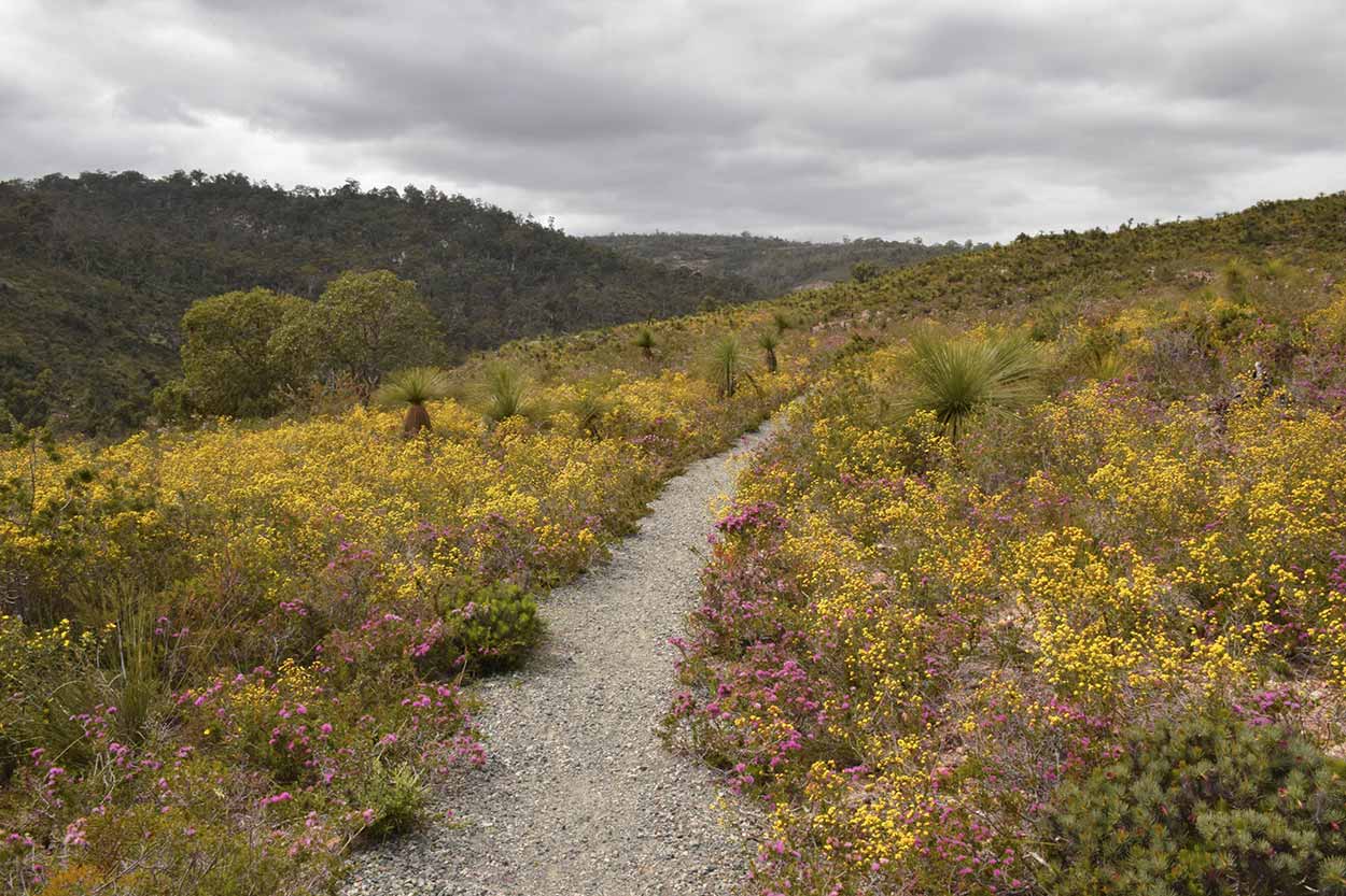
I think the lack of large trees along the Eagle View Trail really brings out the colour of the wildflowers which stretch out into the distance. The tuffs of yellow and pink are the result of differing types of Feather Flower and Starflower.


Apart from the multitude of wildflowers there are also good views over the Swan River Plain towards the Perth CBD skyline.

Pity about the high-tension power lines spoiling the views. It is also a pity about the group of ten people (mainly teenagers) screaming and ruining the ambience. Why aren't the adults in the group telling them to shut up? I try to block out the idiotic, egocentric tripe emitted from the teenager's mouths and instead enjoy the views.


I didn't see any eagles on the Eagle View Trail but I certainly got an Eagle eyes view. For a walk which is only a couple of hundred meters the Eagle View Trail definitely packs in the scenery. I don't think I have ever spent so much time on a path to stop and look at both the long distance views and the intricacies within a few meters. I definitely recommend this springtime walk. Even if you are not an avid hiker this walk is for you, it is right next to the carpark and the path is short and easy to traverse.
After the glories of the Eagle View Trail I take a walk along the Easy Walk Trail ("Easy" because it is short, completely flat and wheelchair accessible). The mascot of the Easy Walk Trail is an echidna, which supposedly call the area home. For those that don't know, an echidna is one of those really strange types of animals found in Australia called a monotreme, an egg laying mammal. Unfortunately, I didn't see a single one of the spiky little buggers around. What I did find was yet again another plethora of wildflowers. The colour of the Easy Walk Trail is not as brilliant as the Eagle View Trail due to less Feather Flower coverage. But if you look closely there are hidden little treasures.


I find myself back at the carpark near the entrance and very content. What a great walk. The most amazing aspect of the Ellis Brook Valley Reserve is that every trail lead to something new. I would walk for a while through areas dominated by a number of different wildflower species and then a short while later be walking through an area with a completely different colour scheme.
Time to walk back to Gosnells train station and make my way back home. Nothing that exciting happened on the way back, but I did notice something on crossing the Tonkin Highway.

Opps ... it does say "It is an offense to enter at this location" but I crossed anyway. I had a look at Section 28 of the Mains Road Act 1930 and couldn't see anything about pedestrians. Think it refers to graziers and I didn't bring my cow for a walk so I guess I am ok. It is a shame there isn't better pedestrian/cyclist access to the Ellis Brook Valley Reserve. For such a Perth gem it really should be better served to the public transport dependant.
Click Here To Read More ...
Click Here To Read More ...
Click Here To Read More ...
View Photographs
Hello, I'm Marc and welcome to metrotrekker.
Be it seeing the city sights, exploring parklands and gardens, urban walks or day-hikes in the city outskirts, the metrotrekker website details walking routes and hiking trails accessible by foot and public transport in metropolitan areas.
The metrotrekker website provides you with all the details required for metropolitan exploration:
- a map with geolocation and a selection of map types (street, satellite, topographical)
- navigation formats compatible with common GPS devices, desktop browser/software or mobile apps
- trail length and difficulty
- start and finish options (particularly by public transport)
- photos/videos
- attractions or points of interest along the way
- other walks and hikes nearby
- often a story or detailed description of the trail (I have personally walked every single trail on the website)
- a comments section, so feel free to write about your experiences as well
- and more improvements and resources are continually being added
So let's get outside and explore our great metropolitan areas by foot. Click Here to begin exploring with metrotrekker.
Pleasant Trails,
Marc
Links To Help You Navigate